


M’en il

raygautier
User
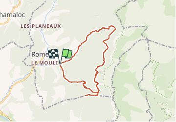

Length
16.3 km

Max alt
1301 m

Uphill gradient
1019 m
Km-Effort
30 km

Min alt
528 m

Downhill gradient
1016 m
Boucle
Yes
Creation date :
2020-07-02 05:58:24.0
Updated on :
2020-07-04 17:13:29.697
5h13
Difficulty : Unknown

FREE GPS app for hiking
 SityTrail
IGN / Geographical institutes
SityTrail Plus
The world is yours!
About
Trail Walking of 16.3 km to be discovered at Auvergne-Rhône-Alpes, Drôme, Romeyer. This trail is proposed by raygautier.
Positioning
Country:
France
Region :
Auvergne-Rhône-Alpes
Department/Province :
Drôme
Municipality :
Romeyer
Location:
Unknown
Start:(Dec)
Start:(UTM)
691460 ; 4960651 (31T) N.
Comments