


raidetoto samedi 4.7.20

Tollard
User
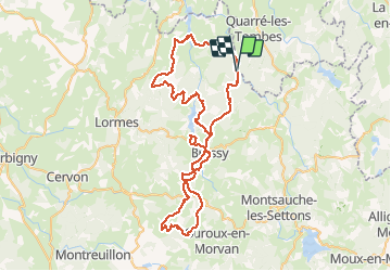

Length
77 km

Max alt
637 m

Uphill gradient
2018 m
Km-Effort
104 km

Min alt
276 m

Downhill gradient
2020 m
Boucle
Yes
Creation date :
2020-07-04 05:55:37.698
Updated on :
2020-07-05 07:11:00.254
7h19
Difficulty : Difficult

FREE GPS app for hiking
 SityTrail
IGN / Geographical institutes
SityTrail Plus
The world is yours!
About
Trail Mountain bike of 77 km to be discovered at Bourgogne-Franche-Comté, Nièvre, Marigny-l'Église. This trail is proposed by Tollard.
Positioning
Country:
France
Region :
Bourgogne-Franche-Comté
Department/Province :
Nièvre
Municipality :
Marigny-l'Église
Location:
Unknown
Start:(Dec)
Start:(UTM)
573457 ; 5242494 (31T) N.
Comments