villers

micheldutilleul
User
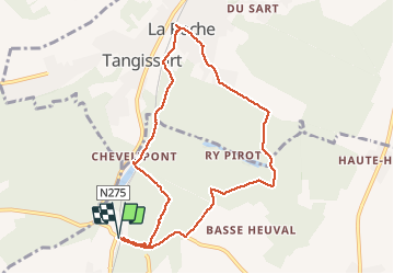

Length
8.2 km

Max alt
154 m

Uphill gradient
191 m
Km-Effort
10.7 km

Min alt
80 m

Downhill gradient
191 m
Boucle
Yes
Creation date :
2020-07-05 13:04:42.34
Updated on :
2020-07-05 14:46:07.345
1h40
Difficulty : Easy

FREE GPS app for hiking
 SityTrail
IGN / Geographical institutes
SityTrail Plus
The world is yours!
About
Trail Walking of 8.2 km to be discovered at Wallonia, Walloon Brabant, Villers-la-Ville. This trail is proposed by micheldutilleul.
Positioning
Country:
Belgium
Region :
Wallonia
Department/Province :
Walloon Brabant
Municipality :
Villers-la-Ville
Location:
Villers-la-Ville
Start:(Dec)
Start:(UTM)
608356 ; 5605258 (31U) N.
Comments