


Taulignan chemin de la soie 4km

thonyc
User GUIDE
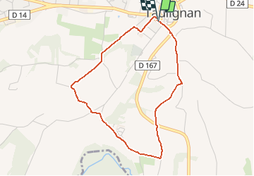

Length
4 km

Max alt
286 m

Uphill gradient
56 m
Km-Effort
4.7 km

Min alt
234 m

Downhill gradient
56 m
Boucle
Yes
Creation date :
2020-07-05 14:21:47.908
Updated on :
2020-07-09 12:23:09.357
1h11
Difficulty : Easy

FREE GPS app for hiking
 SityTrail
IGN / Geographical institutes
SityTrail Plus
The world is yours!
About
Trail Walking of 4 km to be discovered at Auvergne-Rhône-Alpes, Drôme, Taulignan. This trail is proposed by thonyc.
Photos


Positioning
Country:
France
Region :
Auvergne-Rhône-Alpes
Department/Province :
Drôme
Municipality :
Taulignan
Location:
Unknown
Start:(Dec)
Start:(UTM)
657497 ; 4922970 (31T) N.
Comments