


monTherme

Dayoff
User
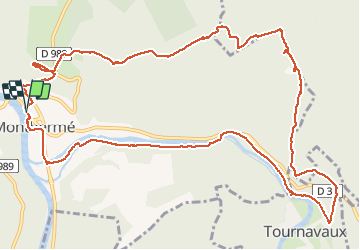

Length
13.9 km

Max alt
422 m

Uphill gradient
434 m
Km-Effort
19.7 km

Min alt
135 m

Downhill gradient
434 m
Boucle
Yes
Creation date :
2020-07-03 09:19:07.415
Updated on :
2020-07-06 10:29:20.623
4h59
Difficulty : Medium

FREE GPS app for hiking
 SityTrail
IGN / Geographical institutes
SityTrail Plus
The world is yours!
About
Trail Walking of 13.9 km to be discovered at Grand Est, Ardennes, Monthermé. This trail is proposed by Dayoff.
Positioning
Country:
France
Region :
Grand Est
Department/Province :
Ardennes
Municipality :
Monthermé
Location:
Unknown
Start:(Dec)
Start:(UTM)
624851 ; 5527396 (31U) N.
Comments