


Lac de la grande Moucherolle

crocau
User
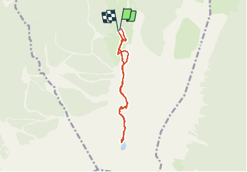

Length
6.1 km

Max alt
2009 m

Uphill gradient
353 m
Km-Effort
10.7 km

Min alt
1721 m

Downhill gradient
347 m
Boucle
Yes
Creation date :
2020-07-06 09:02:21.433
Updated on :
2021-03-31 15:38:49.943
2h19
Difficulty : Very easy

FREE GPS app for hiking
 SityTrail
IGN / Geographical institutes
SityTrail Plus
The world is yours!
About
Trail Walking of 6.1 km to be discovered at Auvergne-Rhône-Alpes, Isère, Villard-de-Lans. This trail is proposed by crocau.
Positioning
Country:
France
Region :
Auvergne-Rhône-Alpes
Department/Province :
Isère
Municipality :
Villard-de-Lans
Location:
Unknown
Start:(Dec)
Start:(UTM)
702419 ; 4989455 (31T) N.
Comments