


G1 Gamay JC

LUCIE2016
User

Length
22 km

Max alt
484 m

Uphill gradient
647 m
Km-Effort
30 km

Min alt
267 m

Downhill gradient
647 m
Boucle
Yes
Creation date :
2020-07-06 06:22:54.948
Updated on :
2020-07-06 12:47:03.69
5h51
Difficulty : Medium

FREE GPS app for hiking
 SityTrail
IGN / Geographical institutes
SityTrail Plus
The world is yours!
About
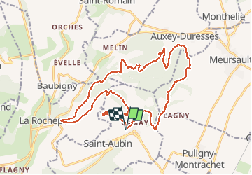
Trail Walking of 22 km to be discovered at Bourgogne-Franche-Comté, Côte-d'Or, Saint-Aubin. This trail is proposed by LUCIE2016.
Positioning
Country:
France
Region :
Bourgogne-Franche-Comté
Department/Province :
Côte-d'Or
Municipality :
Saint-Aubin
Location:
Unknown
Start:(Dec)
Start:(UTM)
630713 ; 5201567 (31T) N.
Comments