


Mont-Dore Station - Col de la Croix Morand

UDGI54
User
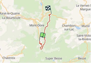

Length
14.7 km

Max alt
1757 m

Uphill gradient
951 m
Km-Effort
27 km

Min alt
1282 m

Downhill gradient
848 m
Boucle
No
Creation date :
2020-07-06 22:41:39.28
Updated on :
2020-07-06 22:41:39.28

FREE GPS app for hiking
 SityTrail
IGN / Geographical institutes
SityTrail Plus
The world is yours!
About
Trail of 14.7 km to be discovered at Auvergne-Rhône-Alpes, Puy-de-Dôme, Mont-Dore. This trail is proposed by UDGI54.
Points of interest


Positioning
Country:
France
Region :
Auvergne-Rhône-Alpes
Department/Province :
Puy-de-Dôme
Municipality :
Mont-Dore
Location:
Unknown
Start:(Dec)
Start:(UTM)
485693 ; 5043498 (31T) N.
Comments