


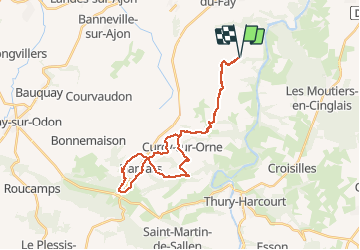
curcy trois monts

albers
User

Length
28 km

Max alt
224 m

Uphill gradient
561 m
Km-Effort
35 km

Min alt
55 m

Downhill gradient
561 m
Boucle
Yes
Creation date :
2016-08-27 00:00:00.0
Updated on :
2016-08-27 00:00:00.0
1h59
Difficulty : Medium

FREE GPS app for hiking
 SityTrail
IGN / Geographical institutes
SityTrail Plus
The world is yours!
About
Trail Mountain bike of 28 km to be discovered at Normandy, Calvados, Montillières-sur-Orne. This trail is proposed by albers.
Description
beau parcours, beaux paysages. belle descentes et que de belles montées....
avec un terrain très gras ça patine, ça patine.
Positioning
Country:
France
Region :
Normandy
Department/Province :
Calvados
Municipality :
Montillières-sur-Orne
Location:
Trois-Monts
Start:(Dec)
Start:(UTM)
684289 ; 5435981 (30U) N.
Comments