


exp_Rando C - Aunay sur Odon.gpx

semaine
User
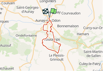

Length
20 km

Max alt
357 m

Uphill gradient
399 m
Km-Effort
26 km

Min alt
123 m

Downhill gradient
399 m
Boucle
Yes
Creation date :
2020-07-08 11:38:52.011
Updated on :
2020-07-08 12:18:20.954
5h30
Difficulty : Very difficult

FREE GPS app for hiking
 SityTrail
IGN / Geographical institutes
SityTrail Plus
The world is yours!
About
Trail Walking of 20 km to be discovered at Normandy, Calvados, Les Monts d'Aunay. This trail is proposed by semaine.
Positioning
Country:
France
Region :
Normandy
Department/Province :
Calvados
Municipality :
Les Monts d'Aunay
Location:
Unknown
Start:(Dec)
Start:(UTM)
673503 ; 5432909 (30U) N.
Comments