


Cognin les gorges il

raygautier
User
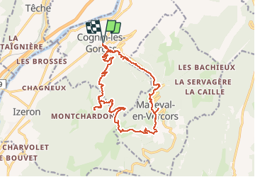

Length
19.8 km

Max alt
1160 m

Uphill gradient
1145 m
Km-Effort
35 km

Min alt
275 m

Downhill gradient
1145 m
Boucle
Yes
Creation date :
2020-07-05 06:43:12.0
Updated on :
2020-07-09 05:40:50.965
5h41
Difficulty : Unknown

FREE GPS app for hiking
 SityTrail
IGN / Geographical institutes
SityTrail Plus
The world is yours!
About
Trail Walking of 19.8 km to be discovered at Auvergne-Rhône-Alpes, Isère, Cognin-les-Gorges. This trail is proposed by raygautier.
Positioning
Country:
France
Region :
Auvergne-Rhône-Alpes
Department/Province :
Isère
Municipality :
Cognin-les-Gorges
Location:
Unknown
Start:(Dec)
Start:(UTM)
689574 ; 5004745 (31T) N.
Comments