


St Jean le t. a Carolles

CANON2
User
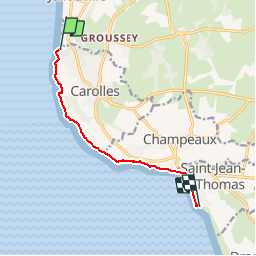

Length
7 km

Max alt
69 m

Uphill gradient
147 m
Km-Effort
9 km

Min alt
8 m

Downhill gradient
147 m
Boucle
No
Creation date :
2019-05-15 13:09:25.249
Updated on :
2019-05-15 13:09:25.356
2h03
Difficulty : Easy

FREE GPS app for hiking
 SityTrail
IGN / Geographical institutes
SityTrail Plus
The world is yours!
About
Trail Walking of 7 km to be discovered at Normandy, Manche, Carolles. This trail is proposed by CANON2.
Positioning
Country:
France
Region :
Normandy
Department/Province :
Manche
Municipality :
Carolles
Location:
Unknown
Start:(Dec)
Start:(UTM)
605005 ; 5401660 (30U) N.
Comments