


Boucle Aussonnelle Garonne Touch

Alouest31
User
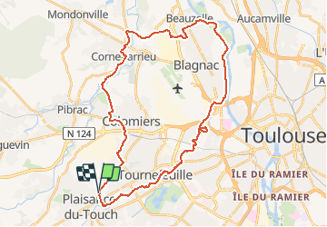

Length
41 km

Max alt
190 m

Uphill gradient
337 m
Km-Effort
46 km

Min alt
122 m

Downhill gradient
335 m
Boucle
Yes
Creation date :
2020-07-09 16:56:47.477
Updated on :
2020-07-11 20:57:10.333
4h00
Difficulty : Difficult
2h30
Difficulty : Easy

FREE GPS app for hiking
 SityTrail
IGN / Geographical institutes
SityTrail Plus
The world is yours!
About
Trail Running of 41 km to be discovered at Occitania, Haute-Garonne, Tournefeuille. This trail is proposed by Alouest31.
Positioning
Country:
France
Region :
Occitania
Department/Province :
Haute-Garonne
Municipality :
Tournefeuille
Location:
Unknown
Start:(Dec)
Start:(UTM)
363069 ; 4825860 (31T) N.
Comments