Druise

raygautier
User

Length
22 km

Max alt
1015 m

Uphill gradient
863 m
Km-Effort
34 km

Min alt
394 m

Downhill gradient
883 m
Boucle
Yes
Creation date :
2020-07-09 05:41:20.0
Updated on :
2020-07-09 17:33:28.091
5h56
Difficulty : Unknown

FREE GPS app for hiking
 SityTrail
IGN / Geographical institutes
SityTrail Plus
The world is yours!
About
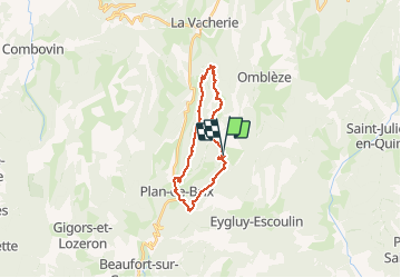
Trail Walking of 22 km to be discovered at Auvergne-Rhône-Alpes, Drôme, Omblèze. This trail is proposed by raygautier.
Positioning
Country:
France
Region :
Auvergne-Rhône-Alpes
Department/Province :
Drôme
Municipality :
Omblèze
Location:
Unknown
Start:(Dec)
Start:(UTM)
673481 ; 4966386 (31T) N.
Comments