


MT DORE 18K

UDGI54
User
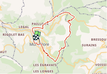

Length
16.9 km

Max alt
1727 m

Uphill gradient
941 m
Km-Effort
29 km

Min alt
993 m

Downhill gradient
900 m
Boucle
No
Creation date :
2020-07-10 11:56:09.501
Updated on :
2020-07-10 11:56:42.31
5h59
Difficulty : Very difficult

FREE GPS app for hiking
 SityTrail
IGN / Geographical institutes
SityTrail Plus
The world is yours!
About
Trail Walking of 16.9 km to be discovered at Auvergne-Rhône-Alpes, Puy-de-Dôme, Mont-Dore. This trail is proposed by UDGI54.
Positioning
Country:
France
Region :
Auvergne-Rhône-Alpes
Department/Province :
Puy-de-Dôme
Municipality :
Mont-Dore
Location:
Unknown
Start:(Dec)
Start:(UTM)
484626 ; 5047204 (31T) N.
Comments