


forêt d'othe 12 . 7 . 20

Tollard
User
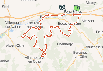

Length
44 km

Max alt
246 m

Uphill gradient
810 m
Km-Effort
55 km

Min alt
127 m

Downhill gradient
824 m
Boucle
No
Creation date :
2020-07-12 06:36:33.948
Updated on :
2020-07-12 20:36:25.892
3h06
Difficulty : Easy

FREE GPS app for hiking
 SityTrail
IGN / Geographical institutes
SityTrail Plus
The world is yours!
About
Trail Mountain bike of 44 km to be discovered at Grand Est, Aube, Fontvannes. This trail is proposed by Tollard.
Description
...du pure Pays d'Othe avec sa forêt, ses single et chemins de vtt, ses vallées avec des villages typiques de la région ESTISSAC VILLEMOIRON BUCEY EN OTHE.....la nature, la quiettude, bref -LE BONHEUR-
Positioning
Country:
France
Region :
Grand Est
Department/Province :
Aube
Municipality :
Fontvannes
Location:
Unknown
Start:(Dec)
Start:(UTM)
564702 ; 5347020 (31U) N.
Comments