


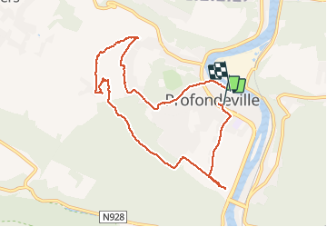
Profondeville point de vue couleuvrine et Serbie

flosart
User

Length
8.6 km

Max alt
268 m

Uphill gradient
275 m
Km-Effort
12.3 km

Min alt
79 m

Downhill gradient
283 m
Boucle
No
Creation date :
2020-07-12 14:28:16.0
Updated on :
2020-07-12 17:15:58.416
2h03
Difficulty : Difficult

FREE GPS app for hiking
 SityTrail
IGN / Geographical institutes
SityTrail Plus
The world is yours!
About
Trail Walking of 8.6 km to be discovered at Wallonia, Namur, Profondeville. This trail is proposed by flosart.
Positioning
Country:
Belgium
Region :
Wallonia
Department/Province :
Namur
Municipality :
Profondeville
Location:
Profondeville
Start:(Dec)
Start:(UTM)
633000 ; 5582209 (31U) N.
Comments
Superbes panoramas Montée un peu difficile mais au final vaut bien l’effort