


randonnee-falaise-d-amont-et-d-aval-a-etretat

gdela
User
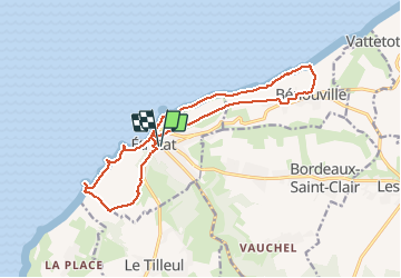

Length
14.9 km

Max alt
99 m

Uphill gradient
335 m
Km-Effort
19.4 km

Min alt
3 m

Downhill gradient
335 m
Boucle
Yes
Creation date :
2020-07-12 21:46:47.112
Updated on :
2020-07-12 21:54:26.808
--
Difficulty : Medium

FREE GPS app for hiking
 SityTrail
IGN / Geographical institutes
SityTrail Plus
The world is yours!
About
Trail On foot of 14.9 km to be discovered at Normandy, Seine-Maritime, Étretat. This trail is proposed by gdela.
Points of interest


Positioning
Country:
France
Region :
Normandy
Department/Province :
Seine-Maritime
Municipality :
Étretat
Location:
Unknown
Start:(Dec)
Start:(UTM)
298523 ; 5509827 (31U) N.
Comments