


randonnee-les-falaises-de-criel-sur-mer-2

gdela
User
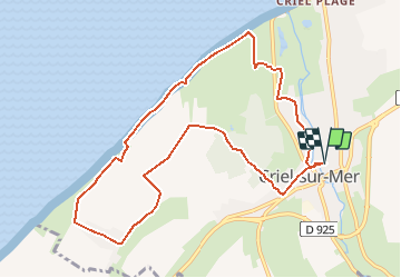

Length
9.6 km

Max alt
111 m

Uphill gradient
217 m
Km-Effort
12.5 km

Min alt
5 m

Downhill gradient
217 m
Boucle
Yes
Creation date :
2020-07-12 21:47:33.411
Updated on :
2020-07-12 21:49:35.687
--
Difficulty : Easy

FREE GPS app for hiking
 SityTrail
IGN / Geographical institutes
SityTrail Plus
The world is yours!
About
Trail On foot of 9.6 km to be discovered at Normandy, Seine-Maritime, Criel-sur-Mer. This trail is proposed by gdela.


Positioning
Country:
France
Region :
Normandy
Department/Province :
Seine-Maritime
Municipality :
Criel-sur-Mer
Location:
Unknown
Start:(Dec)
Start:(UTM)
379381 ; 5541912 (31U) N.
Comments