


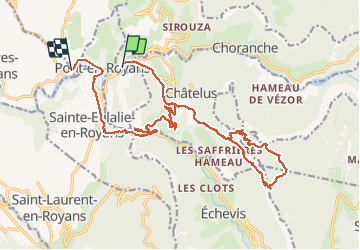
Pont en royans

raygautier
User

Length
23 km

Max alt
1279 m

Uphill gradient
1391 m
Km-Effort
42 km

Min alt
197 m

Downhill gradient
1448 m
Boucle
No
Creation date :
2020-07-14 06:15:28.0
Updated on :
2020-07-14 15:11:17.847
6h09
Difficulty : Unknown

FREE GPS app for hiking
 SityTrail
IGN / Geographical institutes
SityTrail Plus
The world is yours!
About
Trail Walking of 23 km to be discovered at Auvergne-Rhône-Alpes, Isère, Choranche. This trail is proposed by raygautier.
Positioning
Country:
France
Region :
Auvergne-Rhône-Alpes
Department/Province :
Isère
Municipality :
Choranche
Location:
Unknown
Start:(Dec)
Start:(UTM)
684986 ; 4992563 (31T) N.
Comments