


SityTrail - Champeix - Olloix

jeanic63
User
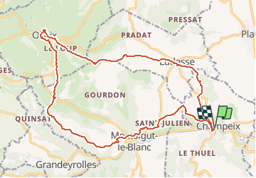

Length
22 km

Max alt
853 m

Uphill gradient
573 m
Km-Effort
30 km

Min alt
461 m

Downhill gradient
572 m
Boucle
Yes
Creation date :
2020-07-15 16:59:41.345
Updated on :
2021-04-08 09:01:31.175
--
Difficulty : Medium

FREE GPS app for hiking
 SityTrail
IGN / Geographical institutes
SityTrail Plus
The world is yours!
About
Trail On foot of 22 km to be discovered at Auvergne-Rhône-Alpes, Puy-de-Dôme, Champeix. This trail is proposed by jeanic63.
Description
Départ Champeix sur la place
Positioning
Country:
France
Region :
Auvergne-Rhône-Alpes
Department/Province :
Puy-de-Dôme
Municipality :
Champeix
Location:
Unknown
Start:(Dec)
Start:(UTM)
510111 ; 5048440 (31T) N.
Comments