


Saint Nectaire les grottes de Chateauneuf

jeanic63
User
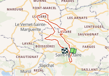

Length
16.2 km

Max alt
1016 m

Uphill gradient
499 m
Km-Effort
23 km

Min alt
682 m

Downhill gradient
502 m
Boucle
Yes
Creation date :
2020-07-15 18:53:15.181
Updated on :
2020-07-15 18:56:24.66
--
Difficulty : Medium

FREE GPS app for hiking
 SityTrail
IGN / Geographical institutes
SityTrail Plus
The world is yours!
About
Trail On foot of 16.2 km to be discovered at Auvergne-Rhône-Alpes, Puy-de-Dôme, Saint-Nectaire. This trail is proposed by jeanic63.
Description
départ parking de la poste rue principale
Positioning
Country:
France
Region :
Auvergne-Rhône-Alpes
Department/Province :
Puy-de-Dôme
Municipality :
Saint-Nectaire
Location:
Unknown
Start:(Dec)
Start:(UTM)
499378 ; 5047919 (31T) N.
Comments