


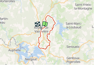
Vassiviere Royeres

csy95
User

Length
21 km

Max alt
777 m

Uphill gradient
400 m
Km-Effort
26 km

Min alt
644 m

Downhill gradient
403 m
Boucle
Yes
Creation date :
2020-07-16 08:02:16.132
Updated on :
2020-07-16 13:22:23.416
4h49
Difficulty : Medium

FREE GPS app for hiking
 SityTrail
IGN / Geographical institutes
SityTrail Plus
The world is yours!
About
Trail Walking of 21 km to be discovered at New Aquitaine, Creuse, Royère-de-Vassivière. This trail is proposed by csy95.
Positioning
Country:
France
Region :
New Aquitaine
Department/Province :
Creuse
Municipality :
Royère-de-Vassivière
Location:
Unknown
Start:(Dec)
Start:(UTM)
415459 ; 5076869 (31T) N.
Comments