


2020 07 MORET T2

michel1025
User
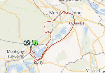

Length
18.1 km

Max alt
105 m

Uphill gradient
161 m
Km-Effort
20 km

Min alt
46 m

Downhill gradient
162 m
Boucle
Yes
Creation date :
2020-07-17 08:04:16.0
Updated on :
2020-07-17 14:42:39.139
5h06
Difficulty : Unknown

FREE GPS app for hiking
 SityTrail
IGN / Geographical institutes
SityTrail Plus
The world is yours!
About
Trail Walking of 18.1 km to be discovered at Ile-de-France, Seine-et-Marne, Montigny-sur-Loing. This trail is proposed by michel1025.
Positioning
Country:
France
Region :
Ile-de-France
Department/Province :
Seine-et-Marne
Municipality :
Montigny-sur-Loing
Location:
Unknown
Start:(Dec)
Start:(UTM)
483391 ; 5354583 (31U) N.
Comments