


saint ferréol- ruine de MONTAIGU

mpstoop
User
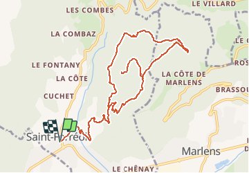

Length
12.9 km

Max alt
1045 m

Uphill gradient
610 m
Km-Effort
21 km

Min alt
518 m

Downhill gradient
611 m
Boucle
Yes
Creation date :
2020-07-17 16:08:36.733
Updated on :
2020-07-19 09:59:26.718
--
Difficulty : Difficult

FREE GPS app for hiking
 SityTrail
IGN / Geographical institutes
SityTrail Plus
The world is yours!
About
Trail On foot of 12.9 km to be discovered at Auvergne-Rhône-Alpes, Upper Savoy, Saint-Ferréol. This trail is proposed by mpstoop.
Positioning
Country:
France
Region :
Auvergne-Rhône-Alpes
Department/Province :
Upper Savoy
Municipality :
Saint-Ferréol
Location:
Unknown
Start:(Dec)
Start:(UTM)
290550 ; 5071558 (32T) N.
Comments