


tedt

dhouet
User
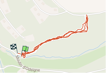

Length
2 km

Max alt
500 m

Uphill gradient
92 m
Km-Effort
3.2 km

Min alt
426 m

Downhill gradient
93 m
Boucle
Yes
Creation date :
2020-07-18 15:30:37.523
Updated on :
2020-07-18 16:11:03.55
39m
Difficulty : Very easy

FREE GPS app for hiking
 SityTrail
IGN / Geographical institutes
SityTrail Plus
The world is yours!
About
Trail Walking of 2 km to be discovered at Wallonia, Luxembourg, Manhay. This trail is proposed by dhouet.
Description
test
Positioning
Country:
Belgium
Region :
Wallonia
Department/Province :
Luxembourg
Municipality :
Manhay
Location:
Odeigne
Start:(Dec)
Start:(UTM)
689770 ; 5570802 (31U) N.
Comments