


lac bussiere galant

mouss65
User
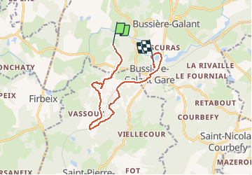

Length
11.2 km

Max alt
454 m

Uphill gradient
168 m
Km-Effort
13.5 km

Min alt
387 m

Downhill gradient
182 m
Boucle
No
Creation date :
2020-07-19 15:32:25.166
Updated on :
2020-07-19 16:35:28.275
1h02
Difficulty : Easy

FREE GPS app for hiking
 SityTrail
IGN / Geographical institutes
SityTrail Plus
The world is yours!
About
Trail Mountain bike of 11.2 km to be discovered at New Aquitaine, Haute-Vienne, Bussière-Galant. This trail is proposed by mouss65.
Positioning
Country:
France
Region :
New Aquitaine
Department/Province :
Haute-Vienne
Municipality :
Bussière-Galant
Location:
Unknown
Start:(Dec)
Start:(UTM)
344866 ; 5053672 (31T) N.
Comments