


2020-07-20_17h50m27_thMeFax7zZs

raab
User
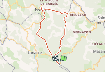

Length
15.7 km

Max alt
1362 m

Uphill gradient
271 m
Km-Effort
19.3 km

Min alt
1188 m

Downhill gradient
271 m
Boucle
Yes
Creation date :
2020-07-20 15:50:27.337
Updated on :
2020-07-20 16:54:15.354
--
Difficulty : Medium

FREE GPS app for hiking
 SityTrail
IGN / Geographical institutes
SityTrail Plus
The world is yours!
About
Trail On foot of 15.7 km to be discovered at Auvergne-Rhône-Alpes, Ardèche, Astet. This trail is proposed by raab.
Positioning
Country:
France
Region :
Auvergne-Rhône-Alpes
Department/Province :
Ardèche
Municipality :
Astet
Location:
Unknown
Start:(Dec)
Start:(UTM)
581836 ; 4952060 (31T) N.
Comments