


chloré

dhouet
User
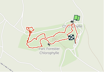

Length
2.4 km

Max alt
511 m

Uphill gradient
51 m
Km-Effort
3.1 km

Min alt
475 m

Downhill gradient
39 m
Boucle
No
Creation date :
2020-07-21 12:48:36.503
Updated on :
2020-07-21 13:55:23.073
1h06
Difficulty : Very easy

FREE GPS app for hiking
 SityTrail
IGN / Geographical institutes
SityTrail Plus
The world is yours!
About
Trail Walking of 2.4 km to be discovered at Wallonia, Luxembourg, Manhay. This trail is proposed by dhouet.
Positioning
Country:
Belgium
Region :
Wallonia
Department/Province :
Luxembourg
Municipality :
Manhay
Location:
Dochamps
Start:(Dec)
Start:(UTM)
685148 ; 5568748 (31U) N.
Comments