


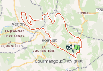
Chevignat-Plain Champs-Mont Verjon

MarcVachet
User

Length
10.7 km

Max alt
506 m

Uphill gradient
327 m
Km-Effort
15.1 km

Min alt
263 m

Downhill gradient
327 m
Boucle
Yes
Creation date :
2020-07-22 06:06:03.982
Updated on :
2020-07-22 09:34:30.648
3h16
Difficulty : Medium

FREE GPS app for hiking
 SityTrail
IGN / Geographical institutes
SityTrail Plus
The world is yours!
About
Trail Walking of 10.7 km to be discovered at Auvergne-Rhône-Alpes, Ain, Courmangoux. This trail is proposed by MarcVachet.
Photos


Positioning
Country:
France
Region :
Auvergne-Rhône-Alpes
Department/Province :
Ain
Municipality :
Courmangoux
Location:
Unknown
Start:(Dec)
Start:(UTM)
683463 ; 5133891 (31T) N.
Comments