


trail treigne

Catherine huppe
User
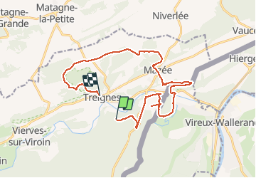

Length
15.4 km

Max alt
264 m

Uphill gradient
430 m
Km-Effort
21 km

Min alt
118 m

Downhill gradient
516 m
Boucle
No
Creation date :
2020-07-22 08:12:11.271
Updated on :
2020-07-22 16:29:35.316
4h56
Difficulty : Easy

FREE GPS app for hiking
 SityTrail
IGN / Geographical institutes
SityTrail Plus
The world is yours!
About
Trail Trail of 15.4 km to be discovered at Wallonia, Namur, Viroinval. This trail is proposed by Catherine huppe.
Positioning
Country:
Belgium
Region :
Wallonia
Department/Province :
Namur
Municipality :
Viroinval
Location:
Treignes
Start:(Dec)
Start:(UTM)
619940 ; 5549485 (31U) N.
Comments