


2020 08 CHAMARANDE T1

michel1025
User
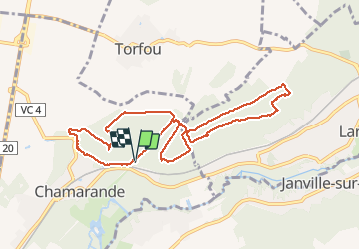

Length
9.6 km

Max alt
163 m

Uphill gradient
161 m
Km-Effort
11.8 km

Min alt
83 m

Downhill gradient
158 m
Boucle
Yes
Creation date :
2020-07-23 07:55:44.0
Updated on :
2020-07-23 10:53:32.62
2h56
Difficulty : Unknown

FREE GPS app for hiking
 SityTrail
IGN / Geographical institutes
SityTrail Plus
The world is yours!
About
Trail Walking of 9.6 km to be discovered at Ile-de-France, Essonne, Chamarande. This trail is proposed by michel1025.
Positioning
Country:
France
Region :
Ile-de-France
Department/Province :
Essonne
Municipality :
Chamarande
Location:
Unknown
Start:(Dec)
Start:(UTM)
442929 ; 5374044 (31U) N.
Comments