


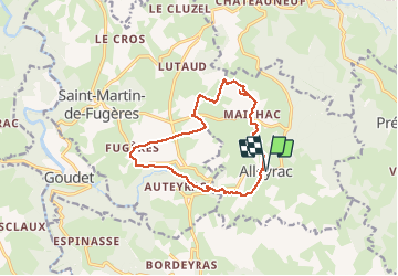
balade alleyrac le moulin du Rocher

raab
User

Length
12.8 km

Max alt
1169 m

Uphill gradient
288 m
Km-Effort
16.7 km

Min alt
964 m

Downhill gradient
288 m
Boucle
Yes
Creation date :
2020-07-23 08:07:16.294
Updated on :
2020-07-23 13:55:11.479
5h45
Difficulty : Easy

FREE GPS app for hiking
 SityTrail
IGN / Geographical institutes
SityTrail Plus
The world is yours!
About
Trail Walking of 12.8 km to be discovered at Auvergne-Rhône-Alpes, Haute-Loire, Alleyrac. This trail is proposed by raab.
Positioning
Country:
France
Region :
Auvergne-Rhône-Alpes
Department/Province :
Haute-Loire
Municipality :
Alleyrac
Location:
Unknown
Start:(Dec)
Start:(UTM)
577877 ; 4971196 (31T) N.
Comments
belle rando aux paysages variés