


VTT Aumont / Chamant

christianH
User
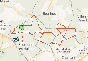

Length
26 km

Max alt
153 m

Uphill gradient
281 m
Km-Effort
30 km

Min alt
87 m

Downhill gradient
286 m
Boucle
No
Creation date :
2020-07-25 07:54:25.276
Updated on :
2020-07-25 10:47:31.097
2h16
Difficulty : Medium

FREE GPS app for hiking
 SityTrail
IGN / Geographical institutes
SityTrail Plus
The world is yours!
About
Trail Mountain bike of 26 km to be discovered at Hauts-de-France, Oise, Aumont-en-Halatte. This trail is proposed by christianH.
Positioning
Country:
France
Region :
Hauts-de-France
Department/Province :
Oise
Municipality :
Aumont-en-Halatte
Location:
Unknown
Start:(Dec)
Start:(UTM)
466731 ; 5454423 (31U) N.
Comments