


la chapelle en valgaudemar 07 2020

jacquesduchesne
User
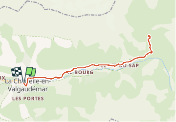

Length
18.9 km

Max alt
1640 m

Uphill gradient
631 m
Km-Effort
27 km

Min alt
1091 m

Downhill gradient
631 m
Boucle
Yes
Creation date :
2020-07-26 07:13:42.662
Updated on :
2020-07-26 09:08:59.057
1h49
Difficulty : Very easy

FREE GPS app for hiking
 SityTrail
IGN / Geographical institutes
SityTrail Plus
The world is yours!
About
Trail Mountain bike of 18.9 km to be discovered at Provence-Alpes-Côte d'Azur, Hautes-Alpes, La Chapelle-en-Valgaudémar. This trail is proposed by jacquesduchesne.
Positioning
Country:
France
Region :
Provence-Alpes-Côte d'Azur
Department/Province :
Hautes-Alpes
Municipality :
La Chapelle-en-Valgaudémar
Location:
Unknown
Start:(Dec)
Start:(UTM)
278111 ; 4966588 (32T) N.
Comments