


Evian le tour du golf

BrassensJC
User
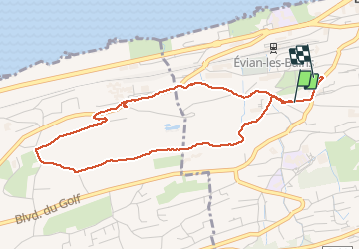

Length
4.7 km

Max alt
505 m

Uphill gradient
85 m
Km-Effort
5.9 km

Min alt
432 m

Downhill gradient
107 m
Boucle
No
Creation date :
2020-07-26 07:37:44.616
Updated on :
2020-07-26 09:31:58.054
1h10
Difficulty : Easy

FREE GPS app for hiking
 SityTrail
IGN / Geographical institutes
SityTrail Plus
The world is yours!
About
Trail Walking of 4.7 km to be discovered at Auvergne-Rhône-Alpes, Upper Savoy, Évian-les-Bains. This trail is proposed by BrassensJC.
Positioning
Country:
France
Region :
Auvergne-Rhône-Alpes
Department/Province :
Upper Savoy
Municipality :
Évian-les-Bains
Location:
Unknown
Start:(Dec)
Start:(UTM)
313915 ; 5140750 (32T) N.
Comments