


Remecourt-10km-gr124a

Djaie60
User
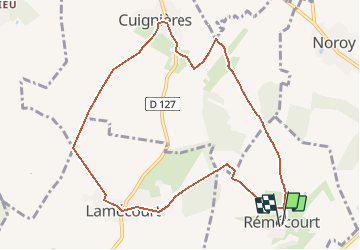

Length
9.6 km

Max alt
159 m

Uphill gradient
184 m
Km-Effort
12.1 km

Min alt
85 m

Downhill gradient
183 m
Boucle
Yes
Creation date :
2020-07-26 10:01:36.0
Updated on :
2021-01-20 15:41:24.677
--
Difficulty : Very easy

FREE GPS app for hiking
 SityTrail
IGN / Geographical institutes
SityTrail Plus
The world is yours!
About
Trail On foot of 9.6 km to be discovered at Hauts-de-France, Oise, Rémécourt. This trail is proposed by Djaie60.
Positioning
Country:
France
Region :
Hauts-de-France
Department/Province :
Oise
Municipality :
Rémécourt
Location:
Unknown
Start:(Dec)
Start:(UTM)
463286 ; 5475219 (31U) N.
Comments