


Groynne 240720

guyernage25
User
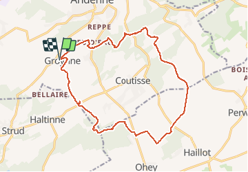

Length
17.1 km

Max alt
284 m

Uphill gradient
381 m
Km-Effort
22 km

Min alt
120 m

Downhill gradient
382 m
Boucle
Yes
Creation date :
2020-07-24 09:07:43.78
Updated on :
2020-07-26 10:10:43.579
3h38
Difficulty : Medium

FREE GPS app for hiking
 SityTrail
IGN / Geographical institutes
SityTrail Plus
The world is yours!
About
Trail Walking of 17.1 km to be discovered at Wallonia, Namur, Andenne. This trail is proposed by guyernage25.
Description
belle rando mi champetre mi boisée avec de belles vues et suivant en partie les sentiers des arts et le GR.
Positioning
Country:
Belgium
Region :
Wallonia
Department/Province :
Namur
Municipality :
Andenne
Location:
Andenne
Start:(Dec)
Start:(UTM)
647638 ; 5592947 (31U) N.
Comments