


Sentier des roches

PMarter
User
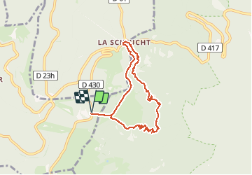

Length
7 km

Max alt
1246 m

Uphill gradient
293 m
Km-Effort
10.9 km

Min alt
996 m

Downhill gradient
293 m
Boucle
Yes
Creation date :
2020-07-26 10:49:00.727
Updated on :
2020-07-26 14:21:15.57
3h31
Difficulty : Medium

FREE GPS app for hiking
 SityTrail
IGN / Geographical institutes
SityTrail Plus
The world is yours!
About
Trail Walking of 7 km to be discovered at Grand Est, Vosges, Xonrupt-Longemer. This trail is proposed by PMarter.
Positioning
Country:
France
Region :
Grand Est
Department/Province :
Vosges
Municipality :
Xonrupt-Longemer
Location:
Unknown
Start:(Dec)
Start:(UTM)
352048 ; 5324007 (32U) N.
Comments