


saucliéres 12

pipette12
User

Length
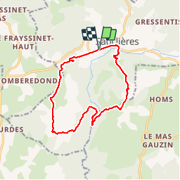
14.5 km

Max alt
906 m

Uphill gradient
415 m
Km-Effort
20 km

Min alt
704 m

Downhill gradient
417 m
Boucle
Yes
Creation date :
2014-12-10 00:00:00.0
Updated on :
2014-12-10 00:00:00.0
4h14
Difficulty : Medium

FREE GPS app for hiking
 SityTrail
IGN / Geographical institutes
SityTrail Plus
The world is yours!
About
Trail Walking of 14.5 km to be discovered at Occitania, Aveyron, Sauclières. This trail is proposed by pipette12.
Description
de saucliéres à gaillac commune de la couvertoirade à la perte de la virenque et retour au départ
Positioning
Country:
France
Region :
Occitania
Department/Province :
Aveyron
Municipality :
Sauclières
Location:
Unknown
Start:(Dec)
Start:(UTM)
528801 ; 4868928 (31T) N.
Comments