


Talensac, juillet 2020

nolsim
User
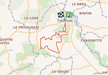

Length
12 km

Max alt
93 m

Uphill gradient
156 m
Km-Effort
14.1 km

Min alt
51 m

Downhill gradient
157 m
Boucle
Yes
Creation date :
2020-07-27 12:17:17.721
Updated on :
2020-07-27 15:05:32.031
2h36
Difficulty : Easy

FREE GPS app for hiking
 SityTrail
IGN / Geographical institutes
SityTrail Plus
The world is yours!
About
Trail Walking of 12 km to be discovered at Brittany, Ille-et-Vilaine, Talensac. This trail is proposed by nolsim.
Positioning
Country:
France
Region :
Brittany
Department/Province :
Ille-et-Vilaine
Municipality :
Talensac
Location:
Unknown
Start:(Dec)
Start:(UTM)
579884 ; 5328892 (30U) N.
Comments