Trail Cycle L'Isle-sur-la-Sorgue - 
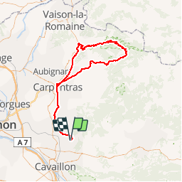
J5_P4_Ventoux_117km_2025m - Photo
 lucienp
lucienp

User

© OpenStreetMap contributors
Length
Length
116 km
Max alt
Max alt
1910 m
Uphill gradient
Uphill gradient
2273 m
Km-Effort
Km-Effort  
147 km
Min alt
Min alt
53 m
Downhill gradient
Downhill gradient
2272 m
Boucle
Boucle
Yes
Creation date :
2016-04-25 00:00:00.0
Updated on :
2016-04-25 00:00:00.0

(0 Reviews)

Cycle
Cycle
8h17
Difficulty : Difficult

Scan this QR Code to open this trail in the SityTrail application

FREE GPS app for hiking

Logo SityTrail SityTrail

IGN / Geographical institutes

Download SityTrail from the App Store Download SityTrail from Google Play

Logo SityTrail SityTrail Plus

The world is yours!

Download SityTrail from the App Store Download SityTrail from Google Play Download SityTrail on Huawei AppGallery

About

Trail Cycle of 116 km to be discovered at Provence-Alpes-Côte d'Azur, Vaucluse, L'Isle-sur-la-Sorgue. This trail is proposed by lucienp.

Description

P4: Isle-sur-la-Sorgue (Domaine du Mousquety), Pernes-les-Fontaines, Carpentras, Caromb, Malaucène, Mont-Ventoux, Chalet Reynard, Bédouin, Carpentras, Pernes-les-Fontaines, Isle-sur-la-Sorgue

P1: en partant de Bédouin vers Malaucène, le parcours fait 55 km avec

P2: en partant de Carpentras, le parcours fait 72 km.

P3: en partant de Pernes-les-Fontaines, le parcours fait 87 km.  

Les 2 parcours P1 et P2 font environ 1906 m de dénivelé.

Elevation profile

Positioning

Country:
France
Region :
Provence-Alpes-Côte d'Azur
Department/Province :
Vaucluse
Municipality :
L'Isle-sur-la-Sorgue
Location:
Unknown
Start:(UTM)
668689 ; 4863580 (31T) N.


Close
My subscriptions