


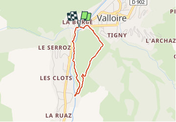
Valloire-La Chapelle Saint-Pierre

Sigmut
User

Length
2.6 km

Max alt
1533 m

Uphill gradient
98 m
Km-Effort
3.9 km

Min alt
1429 m

Downhill gradient
100 m
Boucle
Yes
Creation date :
2020-07-28 08:20:17.035
Updated on :
2020-07-30 21:18:25.562
1h30
Difficulty : Very easy

FREE GPS app for hiking
 SityTrail
IGN / Geographical institutes
SityTrail Plus
The world is yours!
About
Trail Walking of 2.6 km to be discovered at Auvergne-Rhône-Alpes, Savoy, Valloire. This trail is proposed by Sigmut.
Description
Randonnée faite avec un enfant de 3 ans et un de 5 ans.
Photos


Positioning
Country:
France
Region :
Auvergne-Rhône-Alpes
Department/Province :
Savoy
Municipality :
Valloire
Location:
Unknown
Start:(Dec)
Start:(UTM)
297496 ; 5004382 (32T) N.
Comments