


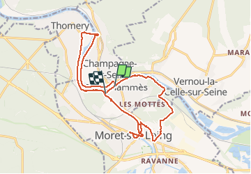
2020 07 MAMMES T1

michel1025
User

Length
18.4 km

Max alt
105 m

Uphill gradient
192 m
Km-Effort
21 km

Min alt
39 m

Downhill gradient
192 m
Boucle
No
Creation date :
2020-07-28 08:02:08.0
Updated on :
2020-07-28 15:19:38.384
5h23
Difficulty : Unknown

FREE GPS app for hiking
 SityTrail
IGN / Geographical institutes
SityTrail Plus
The world is yours!
About
Trail Walking of 18.4 km to be discovered at Ile-de-France, Seine-et-Marne, Saint-Mammès. This trail is proposed by michel1025.
Positioning
Country:
France
Region :
Ile-de-France
Department/Province :
Seine-et-Marne
Municipality :
Saint-Mammès
Location:
Unknown
Start:(Dec)
Start:(UTM)
485694 ; 5359528 (31U) N.
Comments