


la chapelle 07 2020

jacquesduchesne
User
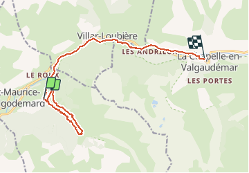

Length
15 km

Max alt
1348 m

Uphill gradient
541 m
Km-Effort
22 km

Min alt
975 m

Downhill gradient
453 m
Boucle
No
Creation date :
2020-07-29 07:23:11.896
Updated on :
2020-07-29 12:15:47.058
4h49
Difficulty : Very easy

FREE GPS app for hiking
 SityTrail
IGN / Geographical institutes
SityTrail Plus
The world is yours!
About
Trail Walking of 15 km to be discovered at Provence-Alpes-Côte d'Azur, Hautes-Alpes, Saint-Maurice-en-Valgodemard. This trail is proposed by jacquesduchesne.
Positioning
Country:
France
Region :
Provence-Alpes-Côte d'Azur
Department/Province :
Hautes-Alpes
Municipality :
Saint-Maurice-en-Valgodemard
Location:
Unknown
Start:(Dec)
Start:(UTM)
271709 ; 4965179 (32T) N.
Comments