


3ponts

Chanchan63
User
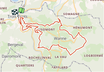

Length
24 km

Max alt
566 m

Uphill gradient
697 m
Km-Effort
34 km

Min alt
250 m

Downhill gradient
693 m
Boucle
Yes
Creation date :
2020-07-27 08:24:14.801
Updated on :
2020-07-29 14:30:06.398
5h18
Difficulty : Very easy

FREE GPS app for hiking
 SityTrail
IGN / Geographical institutes
SityTrail Plus
The world is yours!
About
Trail Walking of 24 km to be discovered at Wallonia, Liège, Trois-Ponts. This trail is proposed by Chanchan63.
Photos


50 photos in total. Please click on a photo to see them all in the gallery.
Positioning
Country:
Belgium
Region :
Wallonia
Department/Province :
Liège
Municipality :
Trois-Ponts
Location:
Fosse
Start:(Dec)
Start:(UTM)
704116 ; 5583951 (31U) N.
Comments