


Algajola-Pigna 9,5 km 244m

DFAL
User
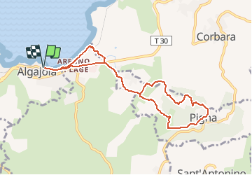

Length
9.5 km

Max alt
221 m

Uphill gradient
244 m
Km-Effort
12.7 km

Min alt
-2 m

Downhill gradient
244 m
Boucle
Yes
Creation date :
2020-07-30 06:37:08.776
Updated on :
2020-07-30 06:39:50.183
2h42
Difficulty : Medium

FREE GPS app for hiking
 SityTrail
IGN / Geographical institutes
SityTrail Plus
The world is yours!
About
Trail Walking of 9.5 km to be discovered at Corsica, Haute-Corse, Algajola. This trail is proposed by DFAL.
Description
Depart Ondine . Montée à Pigna. Retour par la plage
Positioning
Country:
France
Region :
Corsica
Department/Province :
Haute-Corse
Municipality :
Algajola
Location:
Unknown
Start:(Dec)
Start:(UTM)
488817 ; 4717303 (32T) N.
Comments
Très belle rondo