


la chapelle. lechapeauetcassecade 07 2020

jacquesduchesne
User
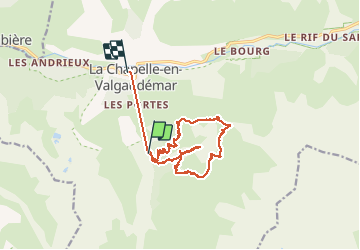

Length
15.7 km

Max alt
2359 m

Uphill gradient
1365 m
Km-Effort
35 km

Min alt
1094 m

Downhill gradient
1579 m
Boucle
No
Creation date :
2020-07-30 06:05:42.962
Updated on :
2020-07-30 16:13:35.012
8h58
Difficulty : Very easy

FREE GPS app for hiking
 SityTrail
IGN / Geographical institutes
SityTrail Plus
The world is yours!
About
Trail Walking of 15.7 km to be discovered at Provence-Alpes-Côte d'Azur, Hautes-Alpes, La Chapelle-en-Valgaudémar. This trail is proposed by jacquesduchesne.
Positioning
Country:
France
Region :
Provence-Alpes-Côte d'Azur
Department/Province :
Hautes-Alpes
Municipality :
La Chapelle-en-Valgaudémar
Location:
Unknown
Start:(Dec)
Start:(UTM)
278571 ; 4964349 (32T) N.
Comments