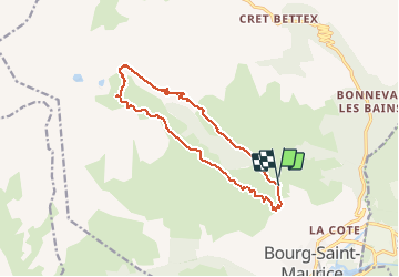
Trail Walking Bourg-Saint-Maurice - les 5 lacs - Photo
 franquen
franquen

User

© OpenStreetMap contributors
Length
Length
14.3 km
Max alt
Max alt
2375 m
Uphill gradient
Uphill gradient
1015 m
Km-Effort
Km-Effort  
28 km
Min alt
Min alt
1366 m
Downhill gradient
Downhill gradient
1041 m
Boucle
Boucle
Yes
Creation date :
2020-07-30 06:42:31.737
Updated on :
2020-07-31 07:26:03.798

(0 Reviews)

Walking
Walking
6h09
Difficulty : Difficult

Scan this QR Code to open this trail in the SityTrail application

FREE GPS app for hiking

Logo SityTrail SityTrail

IGN / Geographical institutes

Download SityTrail from the App Store Download SityTrail from Google Play

Logo SityTrail SityTrail Plus

The world is yours!

Download SityTrail from the App Store Download SityTrail from Google Play Download SityTrail on Huawei AppGallery

About

Trail Walking of 14.3 km to be discovered at Auvergne-Rhône-Alpes, Savoy, Bourg-Saint-Maurice. This trail is proposed by franquen.

Description

rando rendue difficile à cause de l’extrême chaleur. il est préférable de démarrer du fort de la Platte qu'on peut atteindre en voiture. Accueil pittoresque et chaleureux au fort tenu par une famille d'éleveur.

Elevation profile

Positioning

Country:
France
Region :
Auvergne-Rhône-Alpes
Department/Province :
Savoy
Municipality :
Bourg-Saint-Maurice
Location:
Unknown
Start:(UTM)
325324 ; 5056010 (32T) N.


Close
My subscriptions