


le-bois-de-linfernet-a-vtt

jeanboulay
User
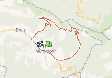

Length
17.9 km

Max alt
1292 m

Uphill gradient
576 m
Km-Effort
26 km

Min alt
727 m

Downhill gradient
571 m
Boucle
Yes
Creation date :
2020-07-31 12:53:28.494
Updated on :
2020-07-31 12:53:28.494

FREE GPS app for hiking
 SityTrail
IGN / Geographical institutes
SityTrail Plus
The world is yours!
About
Trail of 17.9 km to be discovered at Provence-Alpes-Côte d'Azur, Hautes-Alpes, Valdoule. This trail is proposed by jeanboulay.
Positioning
Country:
France
Region :
Provence-Alpes-Côte d'Azur
Department/Province :
Hautes-Alpes
Municipality :
Valdoule
Location:
Montmorin
Start:(Dec)
Start:(UTM)
702121 ; 4925112 (31T) N.
Comments